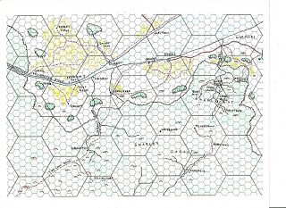
 I’m on a roll! The portion to the north of the Velverdyva is the southernmost portion of the Kingdom of Furyondy. I thought it made more sense to put a lot of farmland there, since it’s supposed to be the breadbasket of the kingdom. That “low road” eventually meanders down to Nulb and a certain village near a certain moathouse…
This map should fit in to the west of the first, shifted down 1/2 large hex. More to come, but I’ll figure out a better way to present them, rather than one map per post.
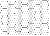
UPDATE: As requested, here is a copy of the blank hex map I’m using to make the maps. I started with a standard sheet of hex paper, and then drew the large hexes in by hand. Feel free to use it as you see fit. Click to embiggen, and then right-click to save to your hard drive.


🙂 You can't see it, but I'm doing the Happy Dance in my recliner.
Heh. Now you're getting into my favorite part of GH….a certain village. 🙂
Very nice …
Do you know about these maps?
http://ghmaps.net/maps.html
Might be worth it to get some kind of consistency between the two.
@Roger the GS:
Those are fine maps too, but they're missing hexes. At least for the DM. I have to have hexes on my world maps. 😉
Actually, Anna Bernemalm's maps are stunning. I would probably use something them for player characters if they went to a cartographer shop.
Ciao!
GW
I like your map. Where did you get that hex paper? I'd like to use it for my campaign. Thanks.
Haldorn: The basic hex paper is standard off-the-shelf stuff. I hand-drew the large hexes on top of it, and then took that to the local Staples to have a bunch of sheets made.
If you want, I'll upload a pdf of a blank sheet for you (and anyone else who might find it of use).
That would be great! Thanks!!!