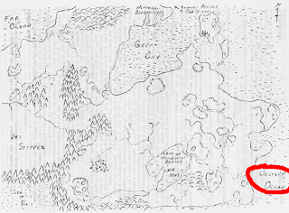
Most Greyhawk fans are well acquainted with Gary Gygax’s pre-Greyhawk map, created for the Castles and Crusades Society shared campaign world (due in large part to Jon Peterson’s masterful history of the early days of the role-playing game hobby, Playing at the World):
I myself have looked at this map dozens of times, charting similarities between it and what would eventually become the map of the Flanaess. But tonight, as I was looking at it to answer a specific question, my eyes lit on a particular label and I noticed something very odd indeed that I never really processed before. I’ve circled it in the above picture.
Why would that particular body of water be called the “Western Ocean” when it is on the eastern side of the continent?
Is it a simple mistake, or could it portend something more interesting? Common sense tells me it’s probably the former, but the DM in me wants to make up some extravagant explanation.


Wasn't Gygax's world theoretically based in/on America? So the Western Ocean is equivalent to the Atlantic, which is west of everything else.
To piggyback John's comment, the Western Ocean could very well have been named by people that lived east of it…
Common sense does suggest it's just a mistake, but that doesn't explain why so many GMs have trouble processing East/West. I've never met anyone who gets North/South confused.
In the upper left corner is the 'Far Ocean' which would further justify the idea that the people naming things lived to the right of the map. i.e. This here is the Western Ocean and way over there the 'Far Ocean'
Perhaps the setting was originally envisioned as a "fantasy North America," as Gary often used later in his works (i.e., Aerth). Thus:
* The Western Ocean is the Atlantic;
* Flannae were native American peoples;
* Eastern Suel were descended from early Viking explorers;
* The Baklunish did not exist, as such, as the West of the land is filled with Neanderthals, Lost World creatures, and the like. Perhaps they are in this early Greyhawk, but corsairs in the southern seas?
* Oerids were descended from the mixed groups of French, Italians, and such that colonized the West.
* Add in that the demi-humans and humanoids settled the West after the rise of the Roman Empire, and you get a situation not unlike that stated at the beginning of later Greyhawk works. With the official Greyhawk, of course, this all got shifted around, but the original elements thus make sense…
Similarly, an argument can be made for similar origins based on the eastern "motherland" being Thuria during the Hyborian Age…
My understanding was that Oerth was a flipped variation of Earth. The oriental (eastern) and occidental (western) features were flipped. So it makes sense that the Western Ocean is east of the coast on this map.