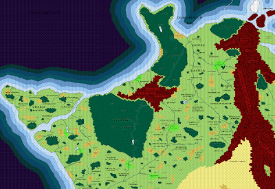
Many moons ago, WotC published a remake of Chainmail, the venerable antecedent of D&D, as a modern miniatures wargame with several factions fighting for control of the panoply of the dead god of war. The setting for the game was called The Sundered Empire, and was deemed canonically to be placed on the far western shore of Oerik!
So naturally when I was doing my Beyond the Flanaess maps, I had to take a stab at it. Since the compilation map of Zindia a few days ago was so popular, I figured I’d try the same with some other major places on Oerth. So here we have the Sundered Empire:
 |
| Click to embiggen |
Wherever the Chainmail game, its supplements, or the wonderful series of Dragon magazine articles that went into more detail about the setting, named a place or a feature, I used that. But to fill in the gaps I had to use my imagination.
According to the Beyond the Flanaess map in Dragon Annual #1, Heward remarks to Mordenkainen that the center of this region is called the Kingdoms of the Marches, “A temperate land filled with princely states. Perhaps another land colonized by seafarers from across the Solnor.” “Princely states” is a way of saying small but independent lands, which is how I characterized what Chainmail would later call “the Disputed Regions;” small petty kingdoms and other free states caught between the major powers on all sides. The second part refers to a possible origin by explorers from the Flanaess, which would be on the other side of the Solnor Ocean.
DA#1’s map lists that wooded peninsula as Elven Lands, and the wooded region southwest of there as “The Elvanian Forest”. This tracks well with the elven Empire of Ravena in Chainmail.
Considering I did these more than five years ago (!) I think they still hold up pretty well, although I might go through and redo the lot of them to add some more stuff to fill in some empty spaces I don’t particularly like. But on the whole, I’m pretty pleased.


Always love some Greyhawk map action. I admittedly never read much on the Sundered Empire, probably biased. I do like how your maps unify the Darlene maps in style. The sheer size of Western Oerik still overwhelms me from a fan standpoint.
Eyeballing it, the Elvanian Forest is as big as the entirety of the Great Kingdom, Sunndi and Nyrond put together. You could campaign in that elven realm and never leave the woods. Of course I'm not saying large woodlands are unrealistic, it just shows how much real estate there is to work with! I like to surmise that the Flanaess was also once one large interconnected woodland that sparsed out over the millennia.
Thank you! I've been looking everywhere for a map of Thalios! By Moradin's Flowing Beard, you wouldn't believe how many weeks I've been sifting through old books and archived PDFs trying to set the groundwork for a new campaign. You're my hero.
Now… I hope I don't sound ungrateful, but I can't read the names of the cities. Is there anywhere I can find a bibliography of major cities in Thalios? At least the ones you displayed in your map?
@Mister Silly, you might want to look at today's blog post. It is relevant to your interests.
YES!!! *Laughs maniacally*
This is awesome! I love it! Thank you!