I’m getting ready to restart the ol’ Greyhawk campaign over the summer, and part of doing so means I’ll be shifting the action from where it left off, in and around the Rift Canyon and Tenh, and moving it down to Greyhawk itself, so the party can not only explore the Castle of the Mad Archmage itself, but also the Kron Hills, Gnarley Forest, Wild Coast, and the cities of Greyhawk, Dyvers, Verbobonc, and Hardby.
So, what’s the first thing I do when I’m getting ready to play? Why, I make maps of course. (I’m not a fan of the “domain of Greyhawk” maps that have appeared in the City boxed set, FtA, and elsewhere.) In this case I am particularly heartbroken, as I had, over the course of years of moves and so forth, gotten rid of an entire series of wilderness maps I had made in college, 5 miles per hex, stretching from Perrenland to Sunndi, and covering most of Keoland into the bargain. Ah, the unlimited time of youth, when you could actually spend the time it takes to do something like that!
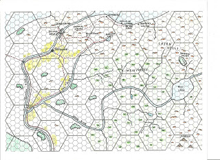
 Well, it’s nothing so grandiose, but if you look at the map above, you’ll see what I’ve started. (The small hexes are 5 miles across, making the large ones 30, the same scale as the poster maps, with roads, trails, farmland, etc. as marked; it’s probably not done yet, as I’ll keep adding little things here and there, but you get the idea.) I’ll probably expand out at least as far south as the Pomarj, and west to cover Verbobonc.
It’s been an interesting exercise, since there are a lot of (sometimes contradictory) sources, some of which I don’t particularly care for. It’s also the case that the campaign is set pre-Wars (and there’s probably no Wars coming, at least the way they were described in Greyhawk Wars and From the Ashes), so a lot of the later material from TSR and WotC needs to be sifted through and the stuff that depends on the Wars excised.
 I’m naturally focusing on the 1980 boxed set, and the Gord the Rogue books, but I’m not throwing out everything from the City of Greyhawk boxed set (that awful map, to be sure), and as I said there are some things in the post-FtA material that is not only useful but downright good. Mostly the stuff that didn’t come about as a result of the Wars.
For the City of Greyhawk, surely a tentpole of such a campaign in and of itself (that’ll be two!), I’ll be relying on Grendelwulf’s excellent ongoing researches, and will be using my own maps for the task, although I’m giving serious thought to taking another pass at them, on graph paper.


Good on you for having 'discriminating taste' on the Greyhawk material that you use.
Also, it's awesome to see cross-pollination between you and Grendelwulf. Between the two of you, that's going to be one hell of a campaign resource…
Yes, for the love of (insert the name of your favorite deity here) please post your Greyhawk wilderness maps!!!!
Wow, I'm trying to get a game together and I was considering starting it in the general vicinity of Greyhawk. I'm thinking of using B2 Keep on the Borderlands, placing it in the Cairn Hills and the moving out from there.
Very nice!
You make me want to draw a detailed 30-mile Greyhawk hex now.
Ciao!
GW
Joe, I don't know how I'm just now seeing this, but this bears a STRIKING resemblance to the 5-mile hex JG-style map I worked up for the area. Great minds, etc.
-DYA
P.S.: Have anything for Hommlet/Kron Hills?
Joe, I don't know how I'm just now seeing this, but this bears a STRIKING resemblance to the 5-mile hex JG-style map I worked up for the area. Great minds, etc.
-DYA
P.S.: Have anything for Hommlet/Kron Hills?
Alas, no; this latest effort only took me as far west as the Gnarley Forest.
But back in college, I had maps of this scale that ranged from Highfolk to Irongate. Lost to the ages, I'm afraid…